

Of all the travelling we've done, I do prefer when we drive ourselves. The independence of movement is a blessed relief - not having to describe, via the medium of not-speaking-your-fucking-lingo, the hotel we wish to be taken to while the driver of a contraption not on speaking terms with physics squints long-sightedly (absolutely without exception, and they also never have their reading glasses) at a proffered phone or reservation slip showing the address in multiple languages.
Anyway, driving in Laos is a blast. The traffic is pretty light and the local car drivers drive in a fashion which I would describe as "pragmatic". They all want to get somewhere and will drive on whichever the side of the road or gap in traffic suits their aims. But they're not twattishly reckless about it and one gets to grips with their particular idiosyncrasies quite quickly. The most common mode of transport is -like everywhere else in this part of the world- the moped. Moped and tuk-tuk traffic is the most alien thing a western driver has to get to cope with here. That and water buffalo. Non-car traffic will pass on either side at any time and you really need to be on your toes. Fortunately, driving the Ford Ranger has height advantages and it's really up to others to not argue with two tonnes of America's finest as you career across a junction after giving up on establishing who has right-of-way.
 |
| How dearly I had missed an engine larger than 1300cc |
We drove to Phonsavan in two stages because the mountain roads are a rocky, winding mess (although still arguably better than Patagonian Argentina) and it's an 8-12 hour drive, depending on vehicle choice, obstacles, and livestock participation.

The first leg terminated in Vang Vieng, a town that is/was big on the backpacker circuit, primarily for the drink, drug and tubing opportunities down by the river. The authorities have cracked down on the revelry recently though (not least because drunk tourists kept offing themselves on the rocks), so I hear the bacchanal is much diminished. We did think about popping down to the bars to see what was going on, but then we figured we'd probably hate it and everyone there, so we sacked it off.
The middle of the town is a massive open gravel-topped area which used to be a CIA runway (designation Sigma 6) for Air America during the Vietnam war years. Not everywhere can say that.
 |
| Huh. |
The following day we drove the other half of the way to Phonsavan. The roads are mostly paved but change to moonscape with no warning, which combined with the road's serpentine nature goes some way to explaining why it takes so damn long to get anywhere.

Passing through the various villages along the way, the houses and community buildings ran the spectrum from rattan walls and rusty corrugated-iron roofs to elaborate and vividly-painted multi-floor houses. I don't know if we were witnessing several stages in the gradual improvement of the villagers lot or just a wild disparity in the distribution of wealth.


Other towns were less fortunate with geography, as they were sending mopeds laden with jerrycans up or down the hill to the nearest tap to bring back for everyone else's use.


One thing that was consistent between the various villages were the flags. All the villages we have driven through were flying the Laos flag and the Hammer and Sickle - the sincerity of which I could not fathom. Laos is a notionally communist country but I think the manner of administration in central government makes little difference to most rural dwellers.


It's definitely one of the more picturesque landscapes we've had the good fortune to travel through, when it wasn't being obscured by the local farmers burning everything. It is also a bit of a shame you can't look at it too far from the road without getting blown up. The tourist board have their work cut out for them on that front.


The whole route is spent dodging goats, cows, water buffalo and pigs.

Concentrating on the big docile quadrupeds, I almost ran this chap over:


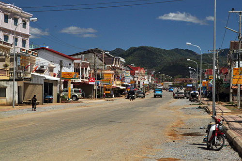
On to Phonsavan, which became the provincial capital when Muong Khoun was literally bombed out of existence during the war. Its a frontier town, but feels a lot like civilisation compared to the villages on the way here. It's not pretty by any stretch of the definition, but it's nice enough. The American-educated Lao lady who runs the Cranky-T cafe in town (recommended, by the way) thought that we must be ex-pats because we were driving ourselves, rather than taking the bus. We're just so goddamn cool.
Back to being serious for a bit. This area, indeed much of the north-east and the majority of the south, is ridiculously contaminated with unexploded ordnance (UXO) from the "Secret War" in Laos conducted by the USA in parallel to the war in Vietnam.

From 1964 to 1973, the U.S. flew 500,000 missions and dropped two million tons of bombs on Laos, two tons for every man woman and child in the country - making it the most heavily bombed country in history. A million tons of that was in the form of cluster munitions, mainly the BLU-26 -canisters filled with 600 tennis ball-shaped bomblets containing a core of explosive and a shell of ball-bearings. Each bomblet (called " bombies" in the Lao vernacular) has an effective range of 500 metres. Of the 270 million cluster munitions deployed in Laos, 30% would fail to detonate for a variety of reasons. This means that by the end of 1973 there were somewhere in the region of 80 million unexploded bombs spread all over the countryside. They are durable and they are by their nature unstable.
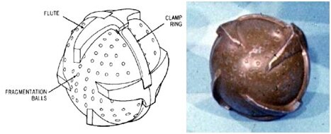 |
| They do look rather unfortunately like toys or fruit |

Since 1974 over 20,000 people have been killed or maimed by UXO, 40% of whom are kids.

Neither the American people nor Congress were told about the campaign, which really kicked off in 1968, following President Johnson’s announcement that all air, naval, and artillery bombardment of Vietnam would cease. Missions were focused on two areas of Laos: in the north they were directed against the North Vietnamese-sponsored Pathet Lao communists who were fighting the CIA-armed Royalist forces; while bombings in the south targeted the Ho Chi Minh Trail in an ultimately futile attempt to cut off supplies being delivered to North Vietnam.

Mostly, during our travels, when we're perusing the museums of local history, the interfering foreign antagonist is the UK. I'm glad it wasn't us this time, because this whole country is hamstrung. Laos is one of the poorest and hungriest countries in the world, racked by corruption at every level of government. If his lot were not bad enough, your average Laotian bloke in a field can't hoe his rice paddy without losing a limb. The kicker is that the land is incredibly fertile here, producing twice the yield of neighbouring countries' fields. But the farmers can't exploit this because they: a) daren't dig deep enough for maximum effectiveness and b) they have to stick to land cleared of ordnance by NGOs like MAG.

Let's talk about them. A British (hurrah!) organisation who employ ex-military engineers and the like to both clear UXOs and train locals to do likewise. Go here and give them all your money. Check out their documentary if you have a moment:
 |
| Like the phrase goes: When life gives you lemons, make boats out of a fucking bomb. |

When walking in the area, you will see markers put there by MAG, indicating that the path has been cleared to a reasonable depth. That's on the white side; the coloured side means that they've only cleared the surface in that direction. So put the shovel away.


There are many sites in the area, but the main archaeological sites are sites 1, 2 and 3, which we drove between. The plain was the site of several pitched battles in the war and are still marked by trenches and bomb craters. The area was heavily bombed and several jars are smashed or cleft cleanly in twain. Several have been vandalised by locals, who have broken them for whet stones and the like.
Roll the photos:


Several trees had grown either around or directly through several of the jars, which was a tad stubborn of them, I thought.


We did try and see the Tad Lang waterfall, as it was signposted up by site 3, but I have just now learned that a new dam has diverted the river away, leaving the falls somewhat badly-named.

Kurzfassung auf Deutsch: Laos ist schlecht mit Blindgängern aus dem Vietnam-Krieg verunreinigt. Die Einheimischen sind sehr arm, und dies macht die Dinge nur noch schlimmer für sie. Wir fuhren auf der Ebene der Tonkrüge in einem Mietwagen, die offenbar sehr ungewöhnlich ist.


